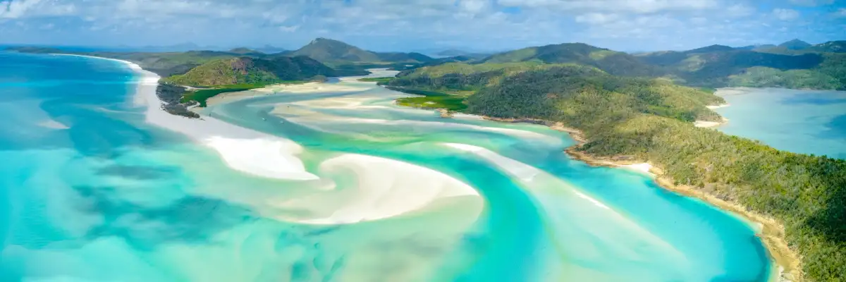
Whitehaven Beach, QLD
Consistently ranked among the most beautiful beaches in the world, Whitehaven Beach stretches over seven kilometres along the eastern side of Whitsunday Island.
Its sand is made up of 98% pure silica, giving it that dazzling white colour that almost glows under the Queensland sun. The swirling patterns where the sand meets the turquoise water at Hill Inlet are some of the most photographed scenes in Australia and it isn’t hard to see why.
While the beach itself is only accessible by boat, seaplane or helicopter, there’s still plenty for 4WD travellers to explore nearby along the mainland coast.
Whitehaven Beach, QLD
Nearby 4WD Tracks
- Cape Gloucester Road – Coastal dirt tracks leading to quiet beaches and lookouts.
- Conway National Park 4WD Tracks – Short rainforest tracks and scenic viewpoints overlooking the Whitsundays.
Camping
- Dingo Beach Camping Area – A laid-back coastal camp spot popular with travellers exploring the Whitsunday hinterland.
- Smalleys Beach Campground – Beachside national park camping accessible by dirt road.
Walls of China, NSW
Rising from the dusty plains of Mungo National Park in NSW, the Walls of China are a series of striking white clay and sand formations sculpted by wind and time.
These fragile lunettes — crescent-shaped dunes formed thousands of years ago — create a maze of ridges, towers and gullies that glow pale white under the harsh outback sun.
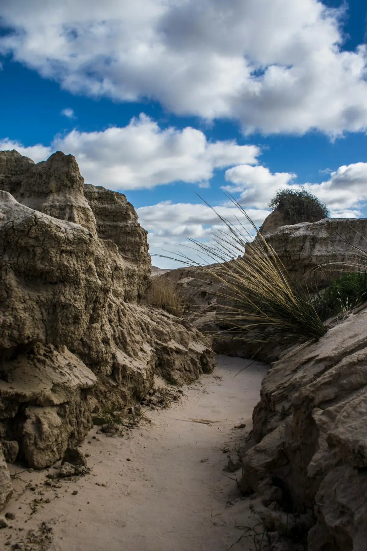
Walls of China, Mungo National Park, NSW
The formations are also part of the Willandra Lakes World Heritage Area, one of Australia’s most significant archaeological regions, where evidence of human habitation stretches back more than 40,000 years.
Walking among the eroded formations feels almost like stepping onto another planet, with the stark white earth contrasting against the surrounding red desert.
Nearby 4WD Tracks
- Mungo Self-Guided Drive Tour – A 70km loop track exploring the park’s main landmarks.
- Old Mail Route Track – Remote outback tracks linking nearby stations and historic routes.
Camping
- Main Campground – A well-equipped campground near the visitor centre.
- Belah Campground – A smaller and quieter bush camping option.
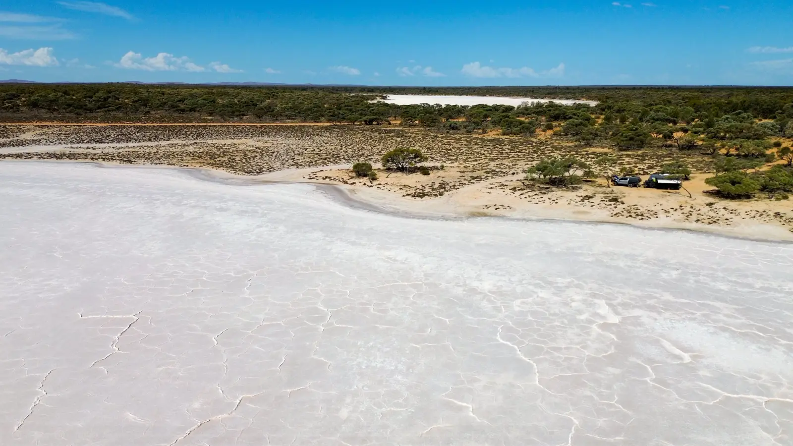
Lake Gairdner, SA
Stretching across more than 160 kilometres in South Australia’s outback, Lake Gairdner is one of the largest salt lakes in the country.
For most of the year, its vast surface appears as a blinding white expanse of salt that shimmers under the desert sun. The lake’s flat, hard surface has even become famous as the site of Speed Week at Lake Gairdner, where land speed racers gather to test their machines on the natural salt flats.
Standing on the lake’s edge, it’s easy to see why the landscape feels so surreal. The bright white ground stretches to the horizon, blending into the pale sky.
Nearby 4WD Tracks
- Gawler Ranges Backroads – Remote outback tracks through rugged volcanic hills.
- Kingoonya Track – An isolated desert route linking small outback settlements.
Camping
- Lake Gairdner Bush Camps – Informal camping areas around the lake’s edge.
- Mount Ive Station Campground – A station stay with facilities and access to nearby tracks.
Australian Alps, NSW, ACT & VIC
When winter arrives, the peaks of the Australian Alps transform into one of the country’s rare white landscapes.
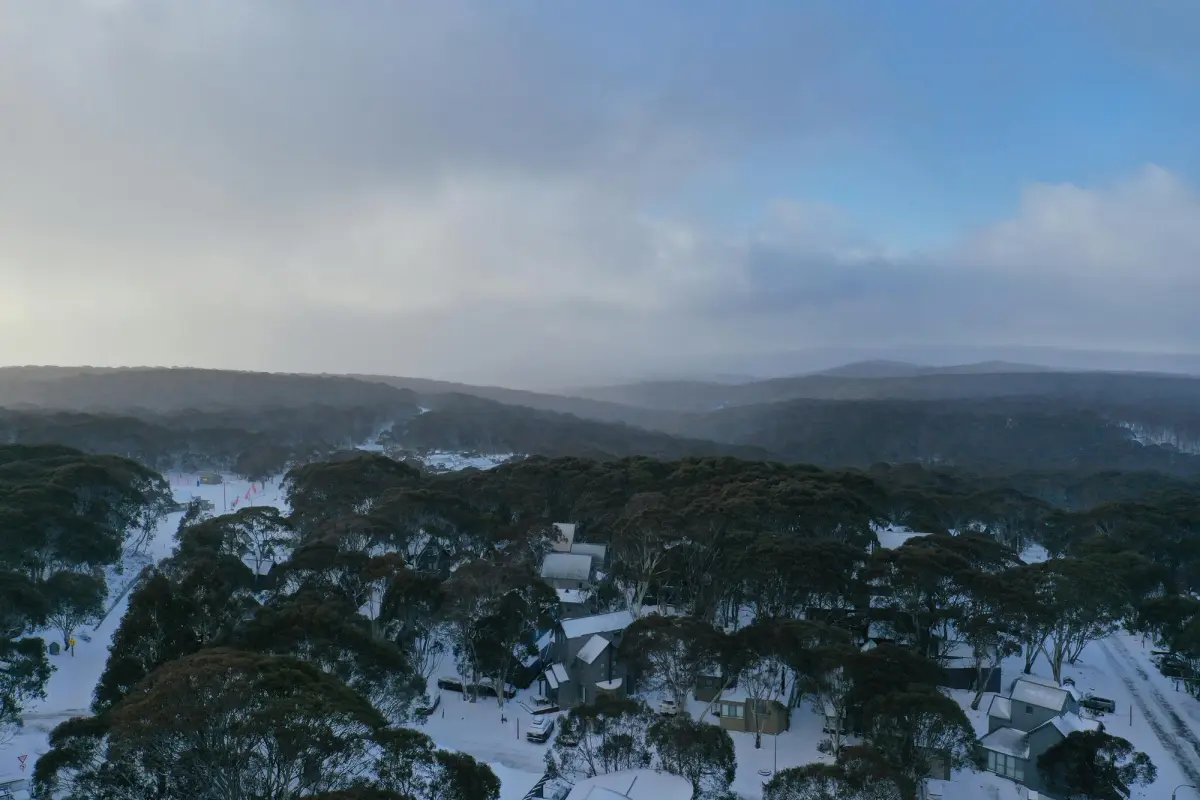
Aerial View of Trees and Houses on a Snowy Hill in Hotham Heights, VIC, Australia
Spanning parts of Victoria, New South Wales and the Australian Capital Territory, the alpine region receives seasonal snowfall that blankets the mountains, forests and high plains in white.
Ski resorts like Mount Hotham, Falls Creek and Perisher attract winter visitors each year, but beyond the resorts the Alps are also home to spectacular alpine drives and high-country tracks.
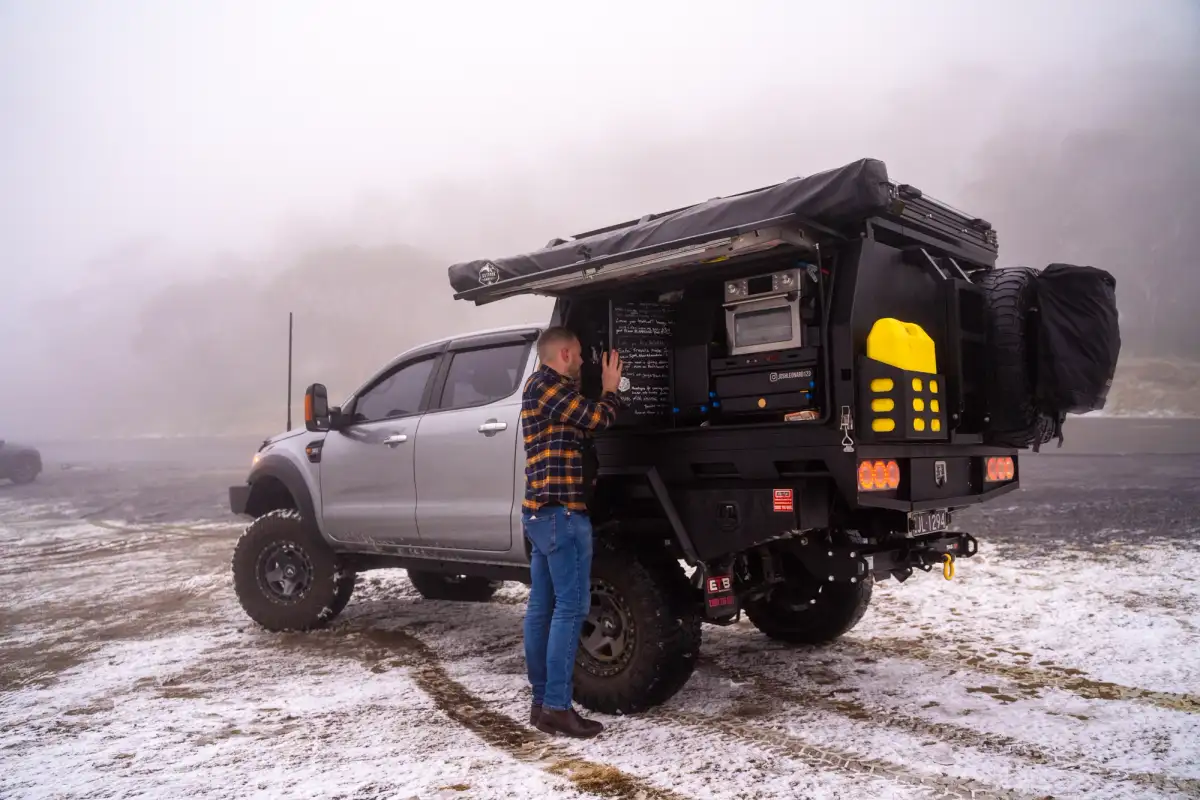
Ford Ranger 4X4 in snowy terrain in the Australian Alps
In summer, the snow melts to reveal green alpine meadows and winding mountain roads that make the region one of Australia’s most scenic touring areas.
Nearby 4WD Tracks
- Blue Rag Range Track – One of the High Country’s most iconic ridge-top drives.
- Davies Plain Track – A challenging and historic high-country route.
Camping
- Pretty Valley Campground – Alpine camping near Falls Creek.
- Davies Plain Hut Campground – Remote bush camping along the Davies Plain Track.
Morning Glory Cloud, QLD
In the remote skies above Gulf of Carpentaria, one of the world’s strangest meteorological phenomena occasionally appears.
The Morning Glory Cloud is a massive, rolling tube-shaped cloud that can stretch for hundreds of kilometres across the sky. From a distance, the formation looks like a giant white wave rolling through the atmosphere.
The phenomenon is most commonly seen near the outback town of Burketown, where unique atmospheric conditions allow the rare cloud formation to develop, particularly during the spring months.
Pilots and photographers often travel to the region hoping to witness the surreal sight as the long white cloud glides silently across the horizon.
Nearby 4WD Tracks
- Savannah Way – An iconic outback route crossing northern Australia.
- Burketown to Gregory Downs Track – A remote Gulf Country drive through wide open savannah.
Camping
- Burketown Caravan Park – A base for travellers hoping to spot the cloud.
- Gregory River Campground – A peaceful bush camping area beside the river.
Escape the city!
Cover anywhere you can legally go in Australia
Part of our complete guide to Australia’s most colourful 4WD destinations.